Project information
- Category: Python, Tensorflow, ML, Keras, PyTorch
- Class: Computer Vision
- Project date: Fall 2023 & Winter 2024
- Project URL: Click Here
Project Details
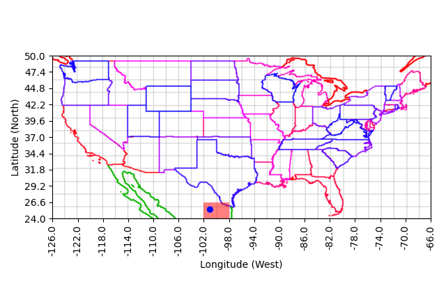
Version 1 of the project involves an AI that guesses a location given a panorama generated from an API, similar to the game Geoguessr. The AI uses random panoramas from Mapillary, converts them into grayscale, and trains a model using Keras from the Tensorflow Python library. After training, the AI makes predictions based on its trained data, with the output showing shaded boxes to indicate confidence levels, and a blue dot to show the actual location. The AI achieves a prediction accuracy rate of 90%. Transitioning to Version 2, we significantly enhanced the project by developing a novel computer vision model that leverages a modified ResNet-50 architecture. This new version accurately identifies geographic locations from images across the United States, regardless of lighting and seasonal variations. By fine-tuning a pre-trained model with a dataset of 61,000 images and innovating with custom layers and a unique Haversine distance-based loss function, we achieved substantial improvements in geolocation accuracy. This advancement underscores the potent applications of machine learning in real-world navigation and location-based services.